


End of The Road? That's the Point.
- Eric Jackson
- Jan 23, 2023
- 8 min read

The Last 10 Shores
Here at the end, as a whole, One Hundred Shores represents the places we can go. Every shore on the list represents an accessible shoreline, beach, or sometimes just a scenic stopover on your trip elsewhere. Most of them are free to access, but the others (state parks, education centers, etc) will be worth the admission required.
Shore 91- Refuge
Dameron Marsh Natural Area
A wide open park on the open Chesapeake in the middle of nowhere? Count me in! Sometimes when you reach the end of the road you find a no trespassing sign, sometimes you find a pot of gold.
It's hard to find a park more at the end of the road than Dameron Marsh Natural Area which is probably why it's such a hot spot for wildlife. Parts of the park are closed through the majority of the year as it's an important nesting ground for various species.
Other than unspoiled nature, you're not likely to find much here, except for your own thoughts and a lot of solitude. Which is probably what you're looking for if you made it this far down the road.

Shore #92 -History Stingray Point, Virginia
“…but our boat by reason of the ebbe, chancing to ground upon a many shoals lying in the entrances, we spyed many fishes lurking in the reeds; our Captaine sporting himself by nailing them to the ground with his sword, set us all a fishing in that manner
Thus we took more in one hour than we could eat in a day. But it chanced our Captaine taking a fish from his sword (not knowing her condition) being much of the fashion of a Thornback [a cow nose ray], but a long tail like a riding rod, whereon the middest is a most poysoned sting, of two or three inches long, bearded like a saw on each side, which she struck into the wrist of his arm near an inch and a halfe: no blood nor wound was seen, but a little blue spot, but the torment was instantly so extreme, that in four hours had so swollen his hand, arm and shoulder, we all with much sorrow concluded his funeral, and prepared his grave in an Island by, as himself directed:
Yet it pleased God by a precious oil Doctor Russell at the first applied to it when he sounded it with probe (ere night) his tormenting paine was so well assuaged that he ate of the fish to his supper, which gave no lesse joy and content to us than ease to himself, for which we called the Island Stingray Isle after the name of the fish.”
In 1608, At the mouth of the Rappahannock, John Smith set out on a little fishing trip during his first expedition to map the Chesapeake. We talk today of targeted species, Smith and crew were a bit more cavalier in their fishing and learned a painful lesson as the story tells. Some stories attribute Smiths recovery to A Rappahannock tribe healer.
Smith described what is now Stingray Point as an island and the shoreline is assuredly very different than what it was 400 years ago. Today the shore is all privately owned, with amazing open bay views and marinas surrounding what is now Stingray Point.

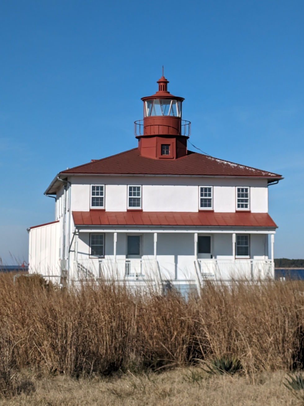
Shore 93 - Change New Point Comfort Lighthouse
The New Point Comfort Lighthouse is another one of those end of the road destinations. Unfortunately here, the road to New Point Comfort ends without a clear view of the majestic lighthouse.
90 years ago, the approach to the light was much different. In fact, you could drive your car straight to the lighthouse. In 1933, a historic hurricane reshaped the peninsula and the New Point Comfort Lighthouse became an island unto itself.
Acreage around the peninsula has continued to disappear with sea level rise- over 1 foot since 1950, and possibly another foot in the years to come. If things don't change.
With sea level rise in a low lying area of partial forest buffer, the salt water will eventually overtake the trees as well as the marsh, leaving a possible ghost forest and a ghost of a shore.
All that aside, the lighthouse is an amazing site if you can get close. When you do eventually reach the end of the road in Mathews, VA, you can catch a distant glimpse of it from a viewing station. A long trip for not a meager reward in my opinion- so bring a kayak and launch from there to paddle the ½ mile or so to the light itself.

Shore 94 - Restoration Piankatank River
Restoration has been one of the most common themes of the entire Chesapeake since President Lyndon Johnson declared it a "National Disgrace" over 50 years ago. In 2014, as part of the Nationally led Chesapeake Watershed Agreement, 5 watersheds in MD and five in VA were selected as targeted sites for large scale oyster restoration. The Piankatank was selected as an ideal site for the effort.
In 2021 the Piankatank was declared by local environmental leaders as the largest completed oyster restoration effort on the planet. Over 400 acres of reef, all in all. It may not be the 8000 estimated acres the Piankatank once held, but it's how recovery starts.
On a different restoration note, the FD Crockett (picture) is docked on the Piankatank at the Deltaville Maritime museum. While it may not be the oldest original vessel on the Chesapeake, the 1924 vessel's superlative is as the last remaining log hulled buy-boat in Virginia. Meaning the hull was originally built from timbers stitched and pinned together, and then carved to shape. The buy-boat was donated in 2005 and has been fully restored to serve as an education exhibit at the museum.

Shore 95 - Trails Monocacy River
An enjoyable paddle on the Monocracy can be tailored to fit just about any length of trip you might want. The northern most publically accessible launch point is north of Frederick at the Creagerstown Park. Floating south you can plan a takeout spot every few miles or so, all the way down to the confluence of the Monocacy and Potomac near
Point Of Rocks.
Recommend early morning for some epic sunrises like these.

Shore 96 - People and Culture West Point
Coincidentally, a lot of the final shores from the journey have been peninsulas. The peninsula formed by the York, Mattaponi, and Pamunkey rivers is symbolic in some way to the convergence of the Mattaponi tribe, Pamunkey tribe and an expanding Virginia colony in the 1600’s. As the colonial territory forced its way outwards, Mattaponi and Pamunkey people were forced into established reservations until those too were relocated.
Today, West Point is a small, mostly residential town with a quaint downtown area. A few miles north, both the Pamunkey and Mattaponi still hold reservations as state recognized indigenous tribes. The Mattaponi hold a nice vineyard overlooking the river which bears the tribal name. The Pamunkey reservation operates a tribal museum overlooking the Pamunkey River as well.

Shore 97 - Access - Magothy River-
This shore was originally going to focus on wildlife. But the truth of the matter is that the real story here on the Magothy, for me, is one of access. For a watershed as densely populated as the Magothy is, there is no public access ramp on the river. In fact, the only public water access at all is a small shoreline on a back creek up river (which is admittedly good for pickerel fishing). It's a heavily wooded shoreline too. At least there's a concrete foundation to play on.
DNR lists the only walk in drop point on the Magothy river at Beachwood Park. The attached photo gives an idea of what accessible looks like here.
As luck would have it, I was planning on visiting this shore for some mid season pickerel fishing this morning when I saw a notice of a public hearing for a proposed boat ramp at Beachwood which would provide boaters access to the river more easily. An actual boat ramp. A reasonable allowance in my opinion. Anne Arundel county citizens can submit public comment. I for one support it.

Shore 98 - Wildlife Pickering Creek Audubon Center
Pickering Creek Audubon Center was a shore brought to my attention by a reader of the newsletter and stories (join in at onehundredshores). The conservation center started from humble beginnings and celebrated it's 40th anniversary last year. The following is a 1982 letter from George Olds who donated the property for conservation. From the Pickering Creek website-
"In the letter [Olds] note that, soon after they inherited the property, they received calls from developers and others who wished to purchase it. They could imagine the 400-acre farm with its 4,400 feet of waterfront turned into building lots, as had happened with similar properties. But they heard other messages, too—ones they attributed to the land’s inhabitants:
“…the calls of the Myrtle Warbler, the Bobolink, Horned Lark and Mockingbird, among others; near sundown in the virgin woods with the 130 foot high Beech trees, hundreds of Vultures come home—gracefully gliding in from the sky and perching silently in the highest branches for the night; along the road between farm and woodland a sign reads “Drive Slow, Beware of Fox Squirrel…”
“And so we decided to donate this land to the Chesapeake Audubon Society…. In lieu of our own quite obvious personal powerlessness to save our small globe, Earth, from eventual ecological destruction—we want those in our immediate greater Community who love the myriad forms of life in Nature to inherit with us now what little we can make available to them, namely the Pickering Creek sample of untrampled land.”
Pretty powerful stuff.

Shore 99 - Landmarks & Icons Jamestown Island
It was tough to settle on a single example of an icon of a watershed with 11000 miles of shoreline. Lighthouses, battleships, skipjacks, etc. The list could stretch on. There's many different stories of Jamestown and the Virginia Company told today, and I'll say that I enjoy every bit of revisionist history ive learned.
Still, there's something inspiring about how Jamestown settlement represents a commitment to a new beginning, a New World, and the exploration of the unknown. There were earlier attempts, and Jamestown certainly faced it hardships, but it represents the ideal of endurance.
Thinking back to last January, I don't know if I really had a clear picture of the endurance it would take to pursue this journey around the Chesapeake. There were certainly moments when I figured I could call it a day and be done with it all. Now, here at the end, there's a tangible feeling of success and completion, but also still a sense of just beginning.

Wildlife
Shore 100- Places Unknown “What will number 100 be?” It’s a question that has been burning hotter and hotter since the time I reached about 75% completion of One Hundred Shores. I didn’t have the answer to it at the beginning. And the one I thought I had a week ago? All of a sudden, it didn't seem quite right. The possible answers kept changing. None of the options really felt like they represented the end of a journey, maybe there really is no end of the road here.
Whatever shore #100 would be, that’s that. That marks the end. Move on.
So, I decided I’d keep this shore a mystery. Some might see it as a bit of a let down, but I’m hoping more will see it as a metaphor for what the whole journey has represented. It’s nowhere particularly special, rest assured. Because the more I think about it, there’s nothing more important about shore 100 than shore 43. Or shore number one. So what purpose does it serve to end with one final shore, as one final representation of all the places I’ve explored?
Hopefully shore 100 will represent a call of the wild. Maybe next time you’re out on a shoreline, you’ll remember the mystery of what that 100th shore might have been. Maybe you’ll walk a little further down the beach, wondering if the mystery is on the other side of that point. If you make the walk, it’ll be worth it, no matter what’s on the other side.
The shirt made from this shore will be for me. Sorry. Probably in a navy blue too. Let's face it, it brings out my eyes. Shirts from the other final shores will be available on the site, and they will all be marked with coordinates. These will be the last shirts- at least for a while- that are individualized with separate gps coordinates. According to my (very sloppy) bookkeeping, there’s close to 400 shirts out there in the wild. Send me a pic of you in yours if you have one, I’d love to add them to my site.


Comments